Map of Seychelles
Home Attractions Activities Accommodation Transportation
Map of Seychelles Islands and the inner islands maps. General facts on Seychelles

Seychelles Maps

Seychelles covers a total area of 455,3 square kilometers and is located in western Indian Ocean, northwest of Madagascar and about 1,600 kilometers (1,000 miles) east of Kenya. It is situated between 4 35 degrees latitude South and 55 40 degrees longitude East.
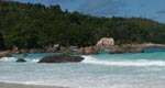
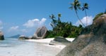
The nation is an archipelago of 115 tropical islands, 41 granitic and about 74 coralline islands.
Mahe is the largest island - 9,142 square kilometers (55 sq. mi.) - and is the site of Victoria, the capital. The coral islands are flat with elevated coral reefs at different stages of formation.
The highest point is Morne Seychellois (905 m) and the lowest point is the Indian Ocean (0 m).

Map of Seychelles
Special Offers
Last minute holidays, cruises, cheap flights and car rental
Travel Insurance
Foreign Currency
General Information
Discover Seychelles a tropical island paradise
Overview
History
People & Culture
Public Holidays
Weather
Photos & Videos
Maps
Visitor Information
Things to know before you go to the Seychelles Islands
Passport & Visa
Travel insurance
Travel advice
Newsletter
Get the latest travel deals by subscribing to our newsletter

About Us  |  Terms of Use  |  Privacy Policy  |  Advertise  |  Help  |  Contact Us  |  Resources  |  Site Map
Copyright © 2006 Exotic Seychelles. All rights reserved